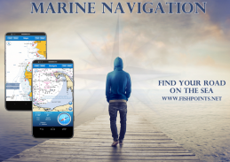
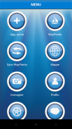
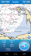
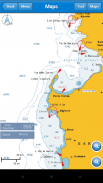
Are you one of those who prefers travelling by their own boat, but worried about getting lost in the ocean? Marine Navigation is one of the best sea GPS trackers which lets you find your road on the sea. It provides one of the most accurate and detailed GPS plotters and is a perfect GPS Chartplotter for boating and sailing.
Marine Navigation comes with everything you should expect from such boating and GPS navigation in sea apps, and it also comes with a super user-friendly and intuitive interface. You just need to browse through different menus of this sea navigation app to completely get the whole idea and get used to working with it. Your ultimate GPS tracker tool is not just about finding the best route while traveling in the sea, as it offers so many other cool features including:
Morse Code in case of danger, Anchor Alert to prevent the drift of the anchor, Moon Phase to show the phases of the moon during the day, Harbors to see the list of ports, Sync Waypoints to be able to create backups and access them from different devices, and Group to go social and share your insights with friends and family.
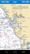
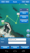
You also get to download the maps and marine charts, so you won’t need an active internet connection when it comes to getting navigation and route planning. If you create a profile, you can save waypoints and routes to access them from different devices. All you have to do is logging in with the same account and enjoy seamless sea GPS navigations.
So, no matter you are a professional sailor or fisherman, or you are an amateur who like traveling in the sea, Marine Navigation has got you covered. It’s a versatile sea navigator app and boating route planner which provides accurate GPS Chartplotter and marine charts. The Social feature is a fun feature which enables you to communicate with different people all around the world who happens to have so many things in common with you, including loving seas, traveling, boating, and sailing.
Marine Navigation: GPS Tracker Main Features at a Glance:
•Super easy to use GPS tracker tool
•Clean and neat design
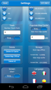
•Available in different languages: English, Italian, French, Spanish, Brazilian, Turkish, Indonesian and German
•Download Maps to use in offline mode
•Accurate and detailed GPS Chartplotter, GPS plotter and Marine charts
•Optimized for phones and tablets
•Sync routes and waypoints to access them anywhere from any devices
•Moon phase
•Morse Code
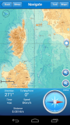
•Receive information about speed, direction, time to arrival
•Compass
•Change Measurement Units: Km, Mi, or Nmi
•Social Feature to share waypoints, images, insights, and live chat
Marine Navigation offers so many features to make sure you don’t need any extra sea GPS tracker tools to carry. It comes with everything you need and you no longer need to worry about finding the route or being lost between waypoints. The Offline Mode lets you freely download the maps and areas and enjoy sea navigation without any connection. The easy to use and learn interface makes sure everyone can get the most out of this sailing GPS app.
Download Marine Navigation and let us know about any bugs, feature requests or any other suggestions. Stay tuned for more features and options in this GPS tracker app for boating.
MAPS AND MARINE CHARTS
More Details: http://www.fishpoints.net/mapsview/
你那些谁喜欢被自己乘船之一,但担心在大海中迷失? 航海导航是最好的海GPS追踪器,它可以让你发现自己在海上的道路之一。它提供了最准确和详细的GPS绘图仪之一,是划船和帆船完美的GPS海图机。
船用导航带有你应该从这样的划船和海上应用GPS导航所期望的一切,而且还配备了一个超级用户友好和直观的界面。你只需要通过这片海域导航应用的不同菜单浏览到完全搞定的整体思路和习惯使用它。你的最终GPS追踪工具不只是找到,而在海上旅行的最佳途径,因为它提供了许多酷炫的功能,包括:
莫尔斯电码在危险情况下,锚警报以防止锚的漂移,月相在白天显示月相,港口以看到端口的列表,同步航点将能够创建备份,并从不同的设备访问它们,和组,进入社会并与朋友和家人分享您的见解。
你也可以在下载的地图和海图,所以当它会得到导航和路径规划,你不会需要一个有效的互联网连接。如果您创建一个配置文件,您可以保存航点和路线,从不同的设备访问它们。所有你需要做的是相同的帐户登录,并享受无缝的海上GPS导航。
所以,无论你是专业水手或渔夫,或者你是谁喜欢在海上旅行,航海导航的业余的一应俱全。这是一个多功能的海上导航的应用程序和划船路线规划提供准确的GPS海图机和海图。在社交的功能是一个有趣的功能,使您能够与不同的人谁恰好有共同的这么多东西和你在一起,包括爱的海洋,旅游,划船和帆船运动在世界各地的交流。
的海洋导航:GPS追踪器主要功能一览:
&公牛;超级好用的GPS追踪工具
&公牛;干净整洁的设计
&公牛;可在不同的语言:英语,意大利语,法语,西班牙语,巴西,土耳其,印尼和德国
&公牛;地图下载到离线模式下使用
&公牛;精确和详细的GPS海图机,全球定位仪和海图
&公牛;优化手机和平板
&公牛;同步航线和航点随时随地从任何设备访问它们
&公牛;月相
&公牛;莫尔斯电码
&公牛;接收有关速度,方向,时间到达信息
&公牛;指南针
&公牛;更改测量单位:公里,MI或NMI
&公牛;社会功能共享的航点,图像,见解和实时聊天
航海导航提供这么多的功能,以确保你不需要任何额外的海上GPS追踪器工具来进行。它配备了你需要的一切,你不再需要担心找不到路线或航点之间丢失。在离线模式,您可以自由下载的地图和地区,享受海上航行,没有任何连接。使用和学习的界面易于确保每个人都可以充分利用这个帆船GPS应用程序。
下载航海导航,让我们知道任何错误,功能要求或任何其他建议。敬请期待划船该GPS跟踪器的应用程序更多的功能和选项。
地图和海图
的 其他细节: 的http://www.fishpoints.net/mapsview/